wind_offshore:geodata
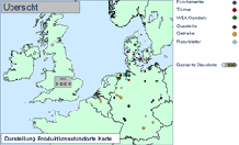
By the wind_offshore:geodata, wind research provides and individually edits data. It offers an extensive service portfolio in the field of GIS (geographic information system), assisting the client in taking decisions e.g. in the planning of offshore wind farms, choice of production sites, logistic concepts, and in the evaluation of wind farms.
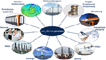
- Based on the value chain of the offshore wind energy, influencing factors are investigated and analysed in a systematic way
- Regarding the first level of the different value creation steps, the value chain for the offshore wind energy is the same as the value chain for onshore wind energy
- Nevertheless, there are some significant differences in the final implementation of the different value creation steps (for example in the field of foundations)
Value chain in the offshore wind energy (level 1)
![]()
(click to enlarge)
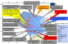
GIS systems can be deployed in the offshore wind energy in various ways:
- Recording and planning of relevant infrastructures for the offshore wind energy
- Supporting investment and site decisions of/ for:
- Turbine manufacturers
- Component suppliers
- Other suppliers
- Companies operating and owning ports
- Logistics companies
- Project developers and turbine operators
- Erection and logistics processes
- Internal controlling and improved transparency
- Illustrating sea routes
- Fault and crisis management
- Data exchange with other institutions/companies
- Data exchange with other applications (SAP, power system controlling technology)
- Providing information, translated into visual results, for clients and for the public
With a GIS, new potentials are discovered in a reliable way; this is why we use our wind_offshore:geodata.


